Montacute House was always one of those places I had passed when travelling through Yeovil and I never thought it was a place worth visiting (how wrong was I!).
I couldn’t find any evidence of Omega signs there so never thought of investigating the area. Then one day I happened to come across an image on Google when looking for another sign which led me to this site: https://www.walkingforum.co.uk/index.php?topic=13041.0
Clearly there are signs in the area! So I started to investigate and could estimate where this sign would be and took to google Streetview to try and find any others. The National Trust Land Map which can be found here: https://www.nationaltrust.org.uk/features/follow-the-history-of-our-places-with-land-map shows the boundary of the land so I scanned the area and after searching Google images I could see there was a couple more signs to be discovered which I could also see on Streetview. Right.. time to head out!
We parked in the Montacute House free car park and headed round the house to soak up the views and atmosphere of the beautiful building and gardens. Then we headed across the park to where I thought the sign above would be. To my disappointment it wasn’t there so maybe I got the location wrong or the National Trust had removed it (as they seem to do from time to time). The blog that showed the sign was from 2011 so it could have been gone for years.
I marked it on my Google map as below:
I have cropped the image above to avoid showing where the other signs are. Sorry but you will have to go hunting for them yourself!
We walked south across the parklands and could see some people coming through a gate which is always a good place to look.
This is a great moment when you see that familiar Omega shape from behind so you know you have found one, but which one is it!!?
Montacute Park!
But this isn’t the sign I spotted on Streetview? My wife has found a bonus one! Kinda makes up for the missing one but I still feel cheated that I could have found more.
We head around the boundary towards Ladies Walk which is another piece of land owned by the trust and I know there is one sign there. We keep the parkland to our left and the hedge on the right and go through a gate heading right and follow a path that leads to the road called Back Lane. There we spot the sign I could see on Streetview!
We turn left at the road and cross Yeovil Road heading for Ladies Walk.
This sign was one I found on Streetview so I was pleased to see it still existed!
This is a circular walk done clockwise and we considered going all the way round but we had to keep an eye on the time. After checking my OS Maps app I decided there was less chance of another sign being on this walk as there weren’t many entrances to the walk round the other side. This is usually where signs reside.
We decided to go anti clockwise as there was a gate a quarter of the way round that led to the road where we could cross and go down another path towards St Michael’s Hill (which is another piece of land owned by the National Trust). There was no omega sign at the gate so we crossed Hollow Lane and down the path towards Abbey Farm.
Passing Abbey Farm I checked the footpath that leads to St Michael’s Hill - no omega there ☹️. We carried on towards the Kings Arms Inn and decided to pop in for a quick half of Thatchers Haze and Scampi Fries!
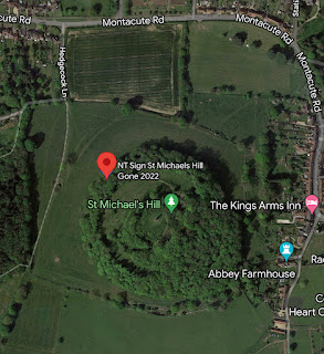
The next leg would be to circumnavigate St Michael’s Hill looking for a sign that I spotted on a Google search. I had a rough idea where it might be - on the entrance from Hedgecock Lane as this seemed logical. We ran short of time so decided to head back to the car park, check out the gift shop at Montacute House then drive to Hedgecock Lane where I would quickly check for the sign.
I got to the gate that gave entrance to the land around St Michael’s Hill and was disappointed to find no omega sign. All that was there was this:
The sign I had spotted online looked like this:
Clearly the location where the mini omega sign is wasn’t the same location as in the picture I found online. The curiosity got the better of me so I decided I had enough time to quickly check round the hill for entrances onto the land where this sign must be!
30 minutes later and return to the car, hot and sweaty and disappointed that the sign was nowhere to be seen. I did find the location of where this sign was by recognising the thick short post and the trees in the background and the obvious hill behind. I marked it on my map as no longer there, started the car and headed home.
The website the picture was from was written 8 years ago so again this sign could have been taken down a long time ago. What I have discovered though… sometimes the Trust puts them back! If you ever go to Montacute, check to see if it’s there and leave a comment!
This is a great area to visit and to hunt for omega signs with plenty of walks, parks to take the dogs and had I made it to the top of St Michael’s Hill, a great view of the surrounding countryside! If you do find any more signs here then please let me know!


Comments
Post a Comment